Mae Yen Waterfall Trek, Pai
Written by Nolo Hub Pai, Pai’s top social and experience-based hostel
Last checked September 2026
tl;dr
Mae Yen Waterfall is one of Pai’s longer jungle hikes, following a stream through the hills east of town to a roughly 30-metre waterfall. The route starts beyond Ban Mae Yen, crosses the stream around 30–40 times each way and ends with a steep climb to the falls.
Also known as: Mae Yen Falls · Namtok Mae Yen · น้ำตกแม่เย็น
- Hiking time
- 6–7 hours of walking, plus your time at the waterfall
- Stream crossings
- around 30–40 each way
- Start of the walk
- 19.361959, 98.462386, where people park
- From Nolo Hub
- 3.6 km to the start of the walk
- Entry
- usually free, but carry 300 baht in case rangers are collecting the national park fee
- Turn around
- start back from the waterfall by 2pm
- Water
- cold, and the pool is shallow
- Before you go
- don't go alone, and tell reception when you expect to be back
- Map
- Google Maps · Apple Maps
Allow 6–7 hours for the hiking, plus time to eat, rest or swim at the waterfall. Start early and keep the whole day free.
Where the trek starts
Use this pin for the start of the walk: 19.361959, 98.462386.
It is where people park. The last stretch to it is a dirt road and not a beginner ride; if you would rather not ride it, park at the end of the paved road and walk the extra 20 minutes.
Make sure you navigate to the trailhead, not the waterfall itself or Wat Phra That Mae Yen. The temple shares the Mae Yen name, but it is a different outing.
Most things here share it, because the stream named them. Mae Yen means “cool river”: แม่ (mae) in front of a stream’s name is short for แม่น้ำ, river, and เย็น (yen) means cool — not “cool mother”, as some translations have it. The village of Ban Mae Yen, the temple above it and the waterfall, น้ำตกแม่เย็น, all take their names from the water.
The waterfall is inside Huai Nam Dang National Park, although the lower trail is not. There is no permanent ticket booth, so the walk is usually free, but rangers sometimes set up a table at the trailhead and collect the park’s 300 baht entry fee. Carry it, just in case.
What the walk is like
The first stretch takes you through more open ground before the path enters the forest and picks up the stream. From there, the water is part of the route: expect to cross it around 30–40 times on the way in and again on the way back. The count can change through the year as the stream shifts across the gravel and seasonal rain changes the crossings.
Your feet are going to get wet. Wear shoes or hiking sandals with good grip that you can comfortably walk in for hours after soaking them. Flip-flops are a poor choice for wet rocks and the climb near the falls.
Much of the walk follows the valley, but the final approach is steeper. For the first 5 km the climb is so gentle it feels flat; over the last 1–1.5 km it rises steeply over a spur before dropping to the pool. The trail leaves the stream and climbs to the waterfall, so keep an eye out for that change rather than following the water indefinitely. If you do not know the route, save a Mae Yen trail track before leaving Pai or go with someone familiar with it. An offline road map may get you to the starting point without showing you the way through the forest.
That climb is one of three places people lose the way. The first 1.5 km runs through orchards and irrigation ditches with farm paths branching off, and it is easy to lose the stream there. About 3.8 km in, a dry side-ravine joins from the north and looks just like the main streambed.
At the waterfall
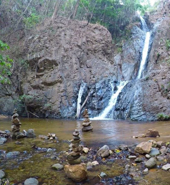
Mae Yen falls into a pool below. Bring lunch and give yourself time to sit down when you arrive; after the walk in, there is no reason to rush straight back. Swimming is possible when the pool and current are suitable, but judge the water as you find it.
The water is cold. Some articles describe it as warm and fed by hot springs; it is not. The pool is shallow, too: the rock here barely wears away, and the stream keeps washing sand and gravel in, so the pool fills faster than the falling water can dig it out.
There are no food stalls or other facilities at the falls. Before settling in, work out when you need to leave to finish the return walk in daylight. As a rule, start back from the waterfall by 2pm. The 6–7 hours above is walking time—your break at the waterfall is extra.
When to go
The cooler, drier months usually make for easier stream crossings. Rain can make the waterfall more powerful, but it can also turn a manageable crossing into one you should not attempt. Rainfall in the hills upstream matters even when it is clear in Pai.
Once you are walking, watch the water. The stream can rise 1.5–2.5 metres within an hour of heavy rain in the hills, even while the sky above you is clear, and once you are in the gorge there is no way out to the side. If it starts rising or turning muddy, turn back. If you are waist-deep, you are off the trail or shouldn’t be out there.
Check local conditions before setting off, particularly in the rainy season. The route may also be closed for part of the year. If the trail is closed or the stream is running high, leave Mae Yen for another day.
What to take
Pack at least 2 litres of drinking water and enough food for a full day, insect repellent, and something to keep your phone and valuables dry. Take swimwear if you want the option of getting in the pool.
There are no shops, bins or toilets past the trailhead, so carry your rubbish back out.
Do not go alone, and tell reception where you are going and when you expect to be back. There is no phone signal in the valley, so the hostel can be the one who notices if you have not come back.